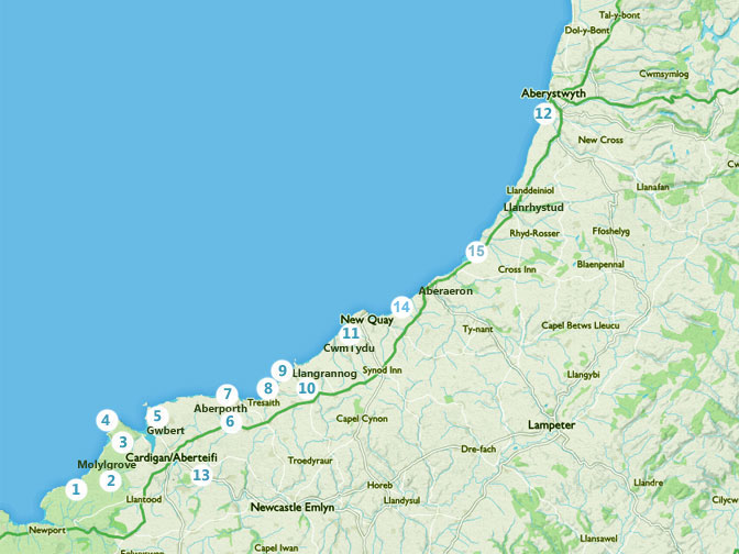
- Moylgrove to Newport
- Circular Moylgrove to Monington
- Cardigan to St Dogmaels
- St Dogmaels to Cemaes Head
- Cardigan to Mwnt to Cardigan
- Walk around Aberporth
- Aberporth to Tresaith
- Tresaith to Penbryn
- Penbryn to Llangrannog
- Walk around Llangrannog
- Cwmtydu to New Quay
- Llanrhystud to Aberystwyth
- Teifi Riverside walk
- New Quay to Aberaeron
The Wales Coast Path is now well established, with clear signing and spectacular walking especially along the stretch from Cardigan to Borth.
The coast and countryside around Cardigan Bay is ideal hiking country, offering a delightful range of walks for both experienced and casual walkers.
Above is a map of some of the circular and linear walks and hikes for you to enjoy around Cardigan Bay. Follow the links above to download the maps, which come complete with useful information on special points of interest along the way.
External link to BBC programme of walk from New Quay to Llangrannog
- Seaside saunters along the fronts of coastal towns and villages
- Literary Trails such as the Dylan Thomas Trail around New Quay
- Delightful strolls along country lanes with ancient hedgerows full of wild flowers
- Invigorating walks across wild headlands with stunning views of the rugged coastline of Cardigan Bay
- Challenging mountain hikes in the remote uplands of the Cambrian Mountains
- Riverside rambles along the Teifi, Aeron Rheidol and Ystwyth valleys.
Cardigan Bay has a number of really useful little buses to help with walks between the hamlets and villages along the coast path. Details of bus routes and timetables here.
Maps for Exploring Cardigan Bay and Ceredigion Coast Path can be found by clicking here
 Note: OS Maps – Explorer maps scale 1:25,000 are used mainly for walking. Landranger maps scale 1:50,000 are better suited for planning a visit to Cardigan Bay. If you prefer the Landranger please choose this map. Cardigan and Mynydd Preseli – OS Landranger Map Sheet 145

Note: OS Maps – Explorer maps scale 1:25,000 are used mainly for walking. Landranger maps scale 1:50,000 are better suited for planning a visit to Cardigan Bay. If you prefer the Landranger please choose this map. Cardigan and Mynydd Preseli – OS Landranger Map Sheet 145
The wild life, flora and fauna of Cardiganshire Coast and Country are truly remarkable. Red Kites and Buzzards soar above whilst Dolphins and seals swim in the bay. Otters rare orchids and hundreds of other plants, birds and animals are all here of you to experience and enjoy.